
Unnamed Peak 6751 m First Ascent Southwest Ridge and West Face Ladakh Himalaya
This mountain has been variously been referred to as Kunchang Kangri, Phurdukpo Kangri I, Unnamed Peak I Kungzang and Mandaltang I. Clearly the mountain has no common name.
Our team left Rongdo village on 9th of July (3200 m) to start the 60 km trek towards the mountain. We trekked three days to base camp (5300 m), making overnight stops in Doksa summer village (4045 m) and Hot Springs (4607 m). BC was established next to the moraine of the Sagtopa glacier (5387 m). Our main objective was the highest summit in the region referred on the “Ladakh and Zanskar North” map by Olizane as being 6721 m and 6751 m on Indian and US maps.
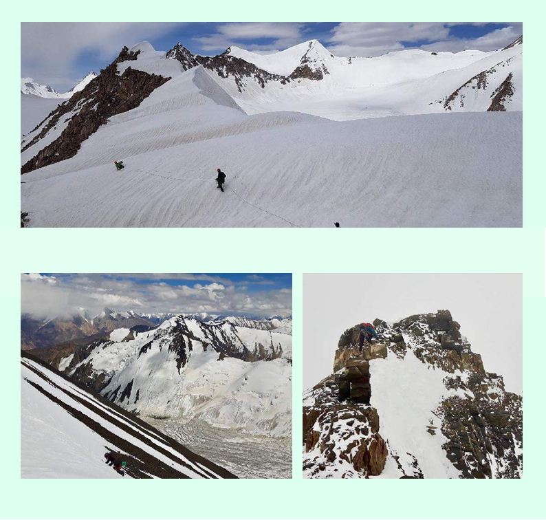
On July 15th we crossed of the southeast Shukpa Kunchang Glacier and established intermediate camp at 5778 m. The glacier was in good shape, covered with strong snow and snow bridges over crevasses, not providing any particular difficulties. Most porters returned then and we
continued with nine porters, sharing load carry ourselves.
The next day we climbed to the col between SE Shukpa Kunchang Glacier and Phurdukpa Glacier, crossing the col at the point 6041 m. The lowest point of the col was at the 5981 m, but heavily corniced and crevassed from the North side, so we had to climb a bit up and find a suitable point to make a 180m rappel. It was the first known crossing of this col, so we named it “Estonian Col”. Our intention was to fix the col with ropes, so as to ferry food and equipment to ABC from BC. Our intention was to make several climbing and exploratory trips from ABC.
Unfortunately the col appeared too steep and crevassed for our remaining 9 porters to make repeated crossings. In addition, we did not have any spare fixed rope to leave there. Therefore we failed to carry out our initial plan for longer climbing trips and concentrated from there on only to the unclimbed peak 6751 m.
On the 19th we moved to the unnamed glacier and, in the worsening weather, established intermediate camp at 5553 m. The next day, our team moved from the glacier to the mountain itself and, next to the rock island, we set up 2nd camp at 5935.53 m. On the 21th we established high camp on the SW ridge at the 6298 m. On the morning of July 22nd the weather was not very promising. It started with snowfall so we had to postpone summit attempt from 2 AM to 4 AM. At 4 AM it was still snowing lightly and winds were noticeable, but we climbed first snow slopes on firm snow. There was an ice step, about 30 meters high (grade WI 3), before entering the couloir leading to under the summit pyramid.
The summit pyramid itself consisted manly of loose rocks and we took utmost care not to drop any stones onto each other heads. Summit was a short knife-edge snow ridge at the height 6801 m. Due to continuously cloudy weather and snowfall, return to the Rongdo valley was more dangerous. Snow-bridges on SE Shukpa Kunchang glacier were softer and Passang Temba Bhutia who was rope- leader on glacier took about five falls into the crevasses.
We measured mountain true height to be 6801 m and this will make it the world's 294th highest mountain, with prominence over 500 meters, and 1041 meters instead of 991 meters.
- Kristjan Erik Suurvali